In This Article
Let’s say you’re hiking in a rural area, and you trip and break your ankle. If you can’t walk out, you may have to call for help on your cell phone—but how will emergency services locate you?
If you’re familiar with cell phone technology, you’d probably answer that the 9-1-1 operator can find your location automatically using the cell phone’s built-in GPS chip. However, most people don’t know that this location data delivery is currently extremely unreliable. Even the FCC admits that this method of emergency geo-location is “not always specific enough for rescue personnel to deliver assistance to the caller quickly.”
The Problem with Cellular Location Data
According to a recent article in USA Today, the FCC has indicated that cell phone location data can be transmitted to emergency services less than 40% of the time. In fact, the FCC has set a goal to reach 40% location data reliability in 2017, and 80% by 2021.
This means that the 9-1-1 operator will most likely not be able to locate you automatically via GPS, and you may be stranded unless you can explain your location in another way. Sadly, there have been many instances of 9-1-1 callers dying before rescue could arrive, as a result of missing GPS location data.
What About Latitude and Longitude?

Tech-savvy smartphone users will likely suggest an alternative method. Assuming you have cell signal, you can use GPS software such as Google Maps to pull up your location in latitude and longitude. While this is a valid method, it poses several problems:
- Most map software requires a cellular data connection (such as WiFi, 3G, or 4G LTE) to work properly. In rural areas, you may have enough cellular signal to call 9-1-1, but no reliable data connection to use map software.
- Latitude and longitude is a complex system based on degrees. It also has multiple versions, which can include decimals, plus, minus, north, south, east, and west components.
- Latitude and longitude requires at least 12 digits to provide location accurate to within 36 feet. It can be difficult to convey all these digits accurately to emergency services.
- If even one digit is misheard or transmitted wrong, or if the incorrect version of latitude and longitude is used, rescue teams can be sent tens of miles in the wrong direction.
The U.S. National Grid
Fortunately, there’s a better system available: the United States National Grid. Despite the name stating “United States”, this coordinate system works anywhere on earth.
This system was developed in by the U.S. Federal Geographic Data Committee, and is similar to national grid reference systems used by many other countries. It also bears resemblance to the Military Grid Reference System (MGRS) used extensively by NATO military forces, and as of October 2015, it is now the official location system used by FEMA.
So, how can regular folks like us tap into the power of this new USNG location system? It’s easy, thanks to a new tool called the USNG App.
Currently, the USNG App is actually just a web site: USNGApp.org (although a proper downloadable app is in development). The site can be visited from any smartphone, tablet, or other device with internet connection* and a GPS chip. You can try visiting it on your home PC, but since it probably lacks built-in GPS, the location will only be accurate to a several-mile radius.
Why You Should Use the USNG App
The USNG App has many advantages over latitude and longitude:
- Instead of degrees and decimals, coordinates are in meters. This makes the system much easier to understand.
- The USNG coordinates can be easily plotted on existing USGS topographical maps and gridded maps using a simple “read right, then up” convention. This makes finding your location on a printed map much easier.
- Using 13 simple characters and no decimals, the USNG can provide a full location accurate within 33 feet (10 meters).
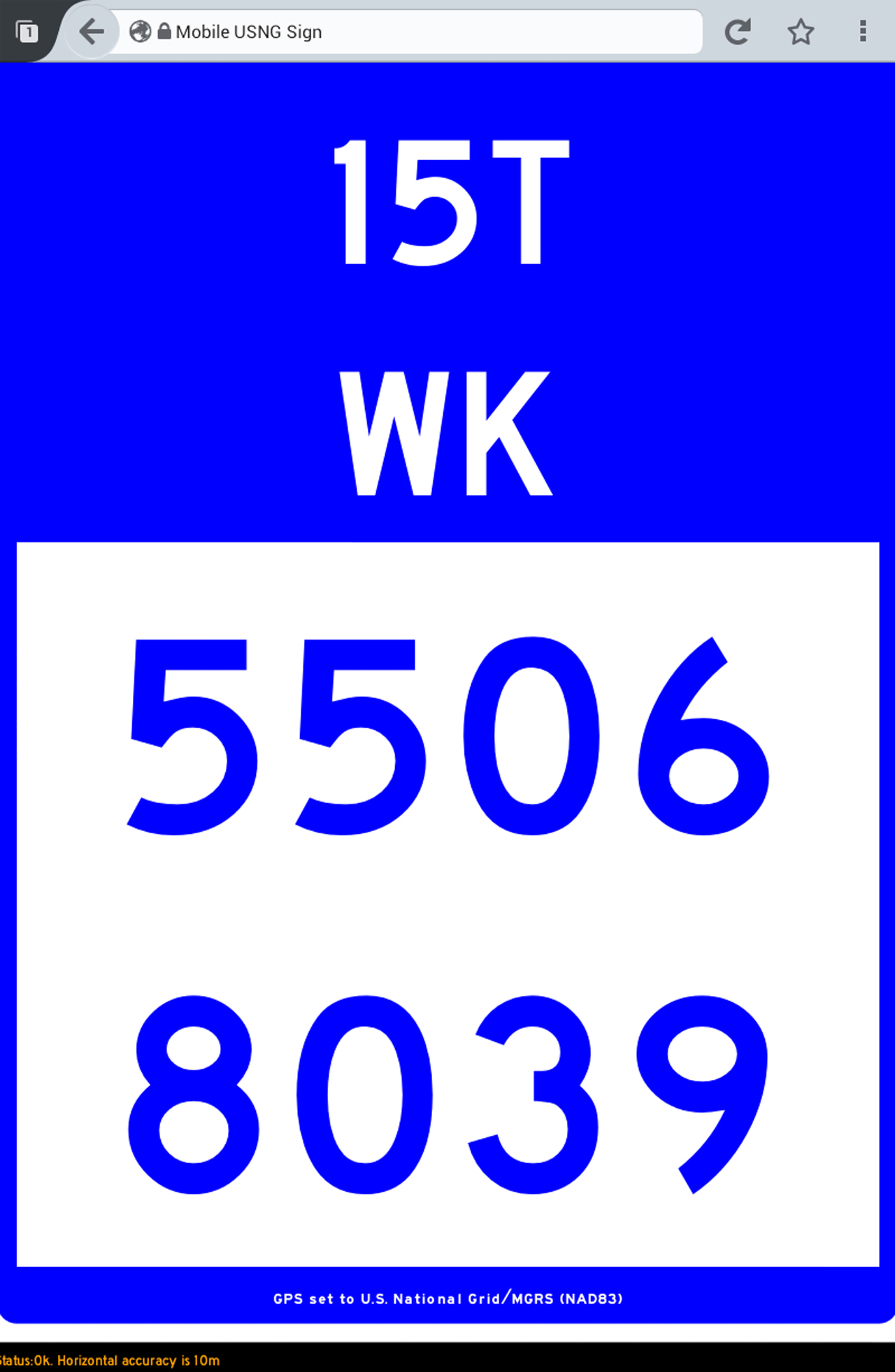
- For local use, such as a 9-1-1 call, you only need to know 8 characters (in the app: 2 blue numbers with 4 digits each).
- For use throughout the entire world, just add the 5 additional characters at the top of the screen (in the app: 2 white numbers and a letter, then 2 more letters).
- The USNG App is smart enough to only display valid data. So, if your GPS signal is inaccurate due to tall buildings or other interference, the app will only give your location within 330 feet or 3300 feet, and will show red lines through the inaccurate digits. (With latitude and longitude, the numbers could be wildly inaccurate, and you’d never know it.)
- An orange “Status” message at the bottom of the page will show the app’s current accuracy and last update time in simple terms.
How to Interpret USNG Coordinates
Here are the basic steps for interpreting USNG coordinates:
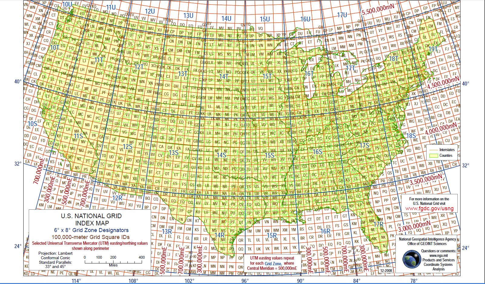
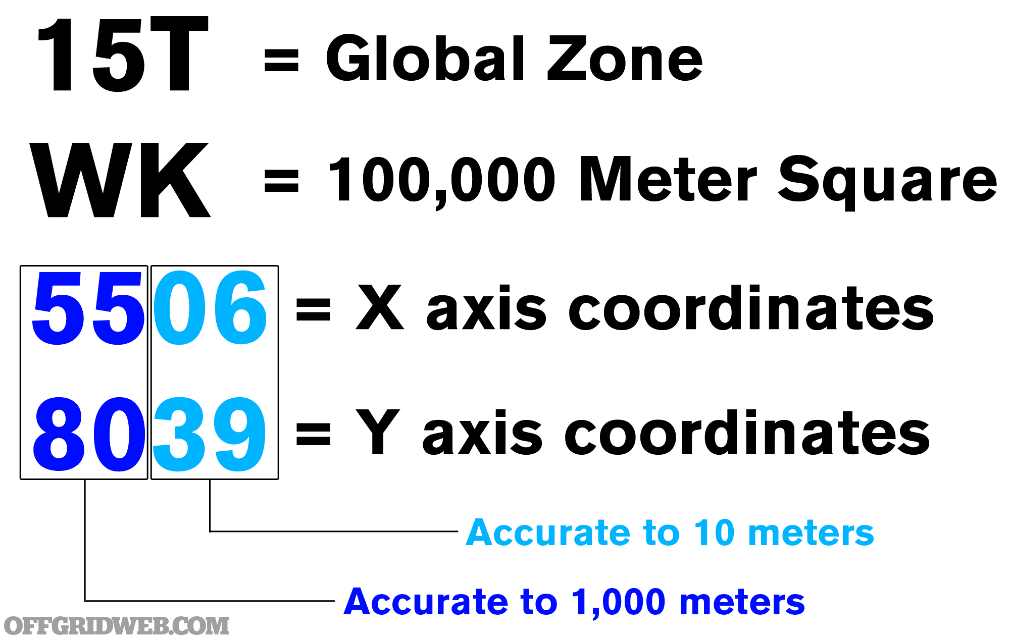
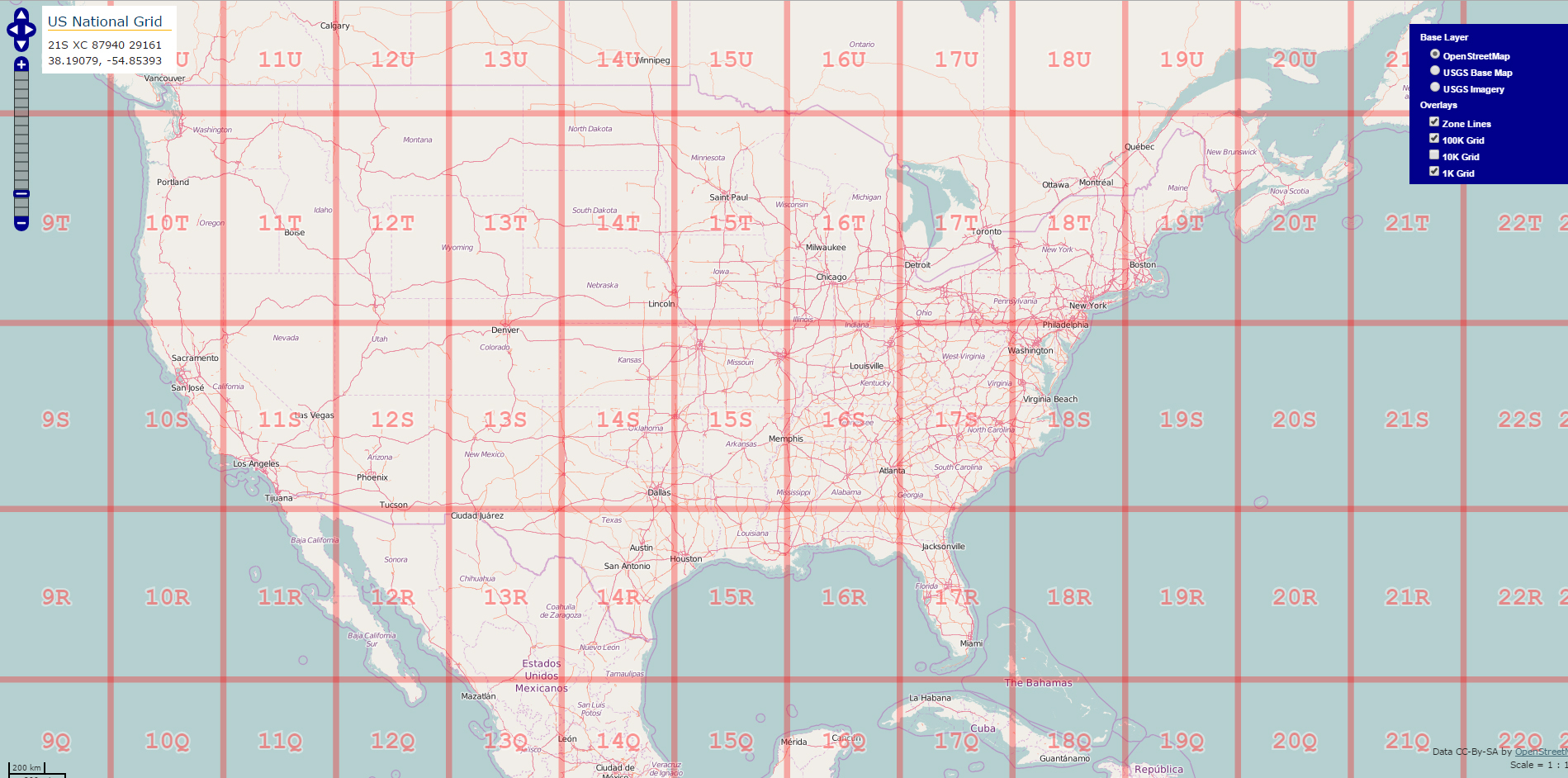 1) Use a USNG reference map, such as this one, to find the Grid Zone. These are the first 3 white characters you see at the top of the app. For example, 15T gives us the Minnesota/Wisconsin/Iowa area.
2) Zoom in further on the map, and find the second set of white characters you see in the app, the 100,000 Meter Square Identification. For example, WK gives us an area to the southeast of Saint Paul, MN.
 3) Next, read the Grid Coordinates, which are the two blue numbers within the white square in the USNG App. Remember: “read right, then up”.
4) The first two digits will be on the X (horizontal) axis, so zoom in and look for 55 on the black 1000-meter grid.
5) Then, read up to find the next two digits, 80. At this intersection (aka 5580), you’ll be within 1,000 meters of the location.
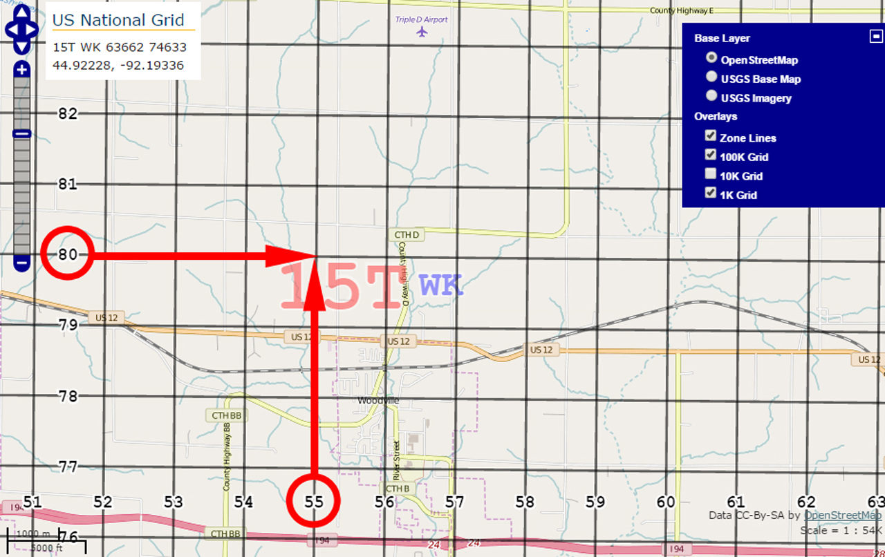
6) Zoom in more, and continue to “read right, then up” to find the second set of X,Y coordinates (aka 0639). This is accurate to 10 meters.
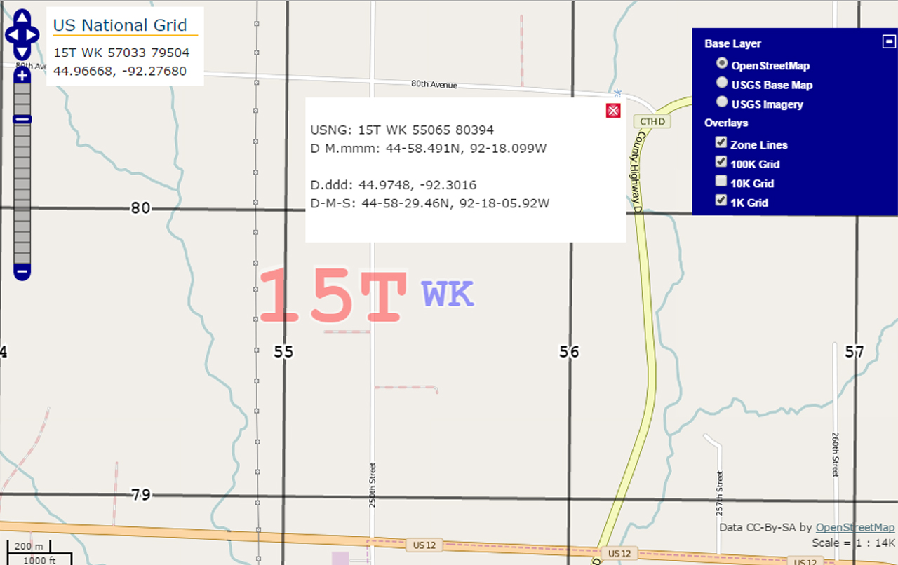
For more information on interpreting USNG coordinates, visit the Federal Geographic Data Committee’s web site. There’s also a free tool called Gmap4, which overlays the USNG on top of Google Maps. Click here to try out Gmap4.
No Internet Connection Required?
Did you notice earlier that we put an asterisk/* next to the phrase “with internet connection”? There’s a reason for that. The very best part about the USNG App is that you only need an internet connection the first time you visit the USNGApp.org web site.
After you visit the USNG App site once, the data that makes the tool work is cached (or temporarily stored) in your device’s browser. Then, as long as your GPS chip is functional and you don’t clear your browser cache, you can open the web page at any time and see your USNG coordinates. No internet connection or cellular data plan required, since everything required to run the tool is stored in your browser’s cache.
Don’t take our word for it—try it for yourself. Go to USNGApp.org on your smartphone. You may be prompted to allow access to GPS location data, so you’ll need to hit “Allow” for the tool to work. Then, close the page, and turn on Airplane Mode to disable your data and WiFi connections. Re-open your browser and go back to the USNG App page. The tool should still work, even without a data connection.
Final Thoughts
Even if you get nothing else from this article, get this: visit USNGApp.org today on your smartphone, and save it as a favorite. You may never end up needing to use the app, but in case you do need it, you’ll have quick access to accurate GPS coordinates for emergencies.
Special thanks to our friend and contributor Andy Schrader for telling us to check out the USNG App.
